Features Reporter
Many students want to see the city of Grand Junction from a new angle: the top of Mt. Garfield. This is arguably one of the most challenging hikes in the Grand Valley.
Graphic Design and Studio Art major Tyler Hansen has hiked Garfield seven times. Although it wasn’t the hardest hike he has done, he admits it is definitely an extreme leg workout due to the steep trail.
Hansen has some advice about the proper gear needed to hike Garfield.
“The gear I recommend people taking is a cell phone for emergency reasons because you are on a lot of open cliff ledges, plenty of water, sunscreen, sun glasses, a hat, good shoes with ankle support, and some good tunes and good friends,” Hansen said. “Just have a good time and make sure you are prepared for the elements. Please respect the trail and environment, and pack out what you pack in.”
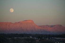
To avoid the intense summer heat, Hansen also encouraged hikers to climb Garfield during a full moon with a head lamp.
Anna Dunn is a Geology major at CMU and has hiked Garfield twice.
“I would definitely recommend this hike to anyone capable,” Dunn said. “The hardest part is the very beginning, going up the near-vertical Mancos Shale.” There are a few nerve-racking parts where you are exposed to falling as well.”
Dunn’s favorite part was standing atop the mountain overlooking the Grand Valley.
“The top is so awesome,” Dunn said. “On a clear day, you can see the LaSalles, the San Juans and as far into Utah as your vision will allow.”
To get to the trailhead, take I-70 to Palisade Exit 42. Turn south on 37 3/10 Road. Take your first right at G 7/10 Road immediately past the canal. Travel almost two miles until the road veers right and follow it under the Interstate to the parking lot.
From the trailhead, there are two trails to reach the top. One route is the Mt. Garfield Trail which goes straight up the Mancos Shale. It is half a mile shorter than the other trail, but steeper. This route gains 2,000 feet of elevation in just two miles. Needless to say, it is quite a challenge. The Gearhart Mine Trail is east of the parking lot. It is slightly longer but less strenuous.
Climbers often report finding fossils along the trail and occasionally see wild horses at the top. There are also old mines, but hikers should never explore them due to deadly gasses that have killed hikers in the past.
Recent Comments